Note: Walker Mangum has a very detailed chart of the approach to Anegada
here.
WGS-84 coordinates are included to assist you, should you want to use GPS as a back up to your
navigation. The center of the entrance to the Anegada channel 18° 42.811'N and 064° 23.668'W. The red
entrance buoy is 18° 42.784'N and 064° 23.651'W. The green entrance buoy is 18° 42.836'N and 064° 23.671'W.
A safe approach waypoint one mile SSW of the entrance is 18° 42.100'N and 064° 24.200'W
Sailing direct to the Anegada channel entrance from the Virgin Gorda will take you close to some coral shoals,
so be certain not to run east of the rhumb line.
An approximate 1 knot current will set you west, at times slightly stronger through the Necker Island Passage
on the first half of the passage. The current abates once you are abeam Horseshoe Reef. In addition, prevailing
winds are from the east, so leeway will further set you to the west, so be sure to steer east of the track course
to counter both of these influences. It is noted that a sailboat making good 7 or 8 knots should steer 8 to 10
degrees east of rhumbline magnetic course.
f you do not have GPS, by far the best way to keep abreast of your actual position is to take regular
two-bearing fixes on the prominent landmarks and draw these off on your chart to note if you are being set
to the east or west of your rhumb line.
Remember: Safe water is to port!
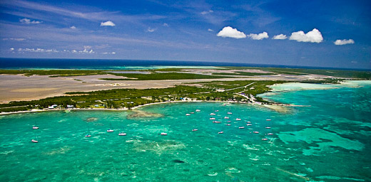
Unlike her sister islands in the British Virgin Islands, Anegada's highest point above sea level is only
28 feet. On the approach, you will see trees, then yachts, and then land. Use the masts to distinguish
anchorages from the West End through Setting Point. Anegada is visible from about 4 to 6 nautical miles
out if the air is not hazy. You will certainly want your binoculars on deck as you make the final approach,
so that you may pick out the first of the channel markers.
You will be able to distinguish Pomato Point as the first large group of trees you come to as you scan from
the West End, and along a long golden sandy beach which has a small cluster of houses at it's centre.
Almost all of the trees are irregular Australian pines (casuarina). The cautious navigator will head for
the middle of the beach on the West End rather than Pomato Point before the channel markers are sighted.
Just to the southeast and only 300' from the outer red channel marker are the "Two Sisters", which are only a
few feet beneath the water. "Prawny Shoal" is another hazard very close to the east of the Virgin Gorda rhumb
line. Again, a cautious approach is essential. If you are coming from Scrub Island or Great Camanoe, once you
see the white roof at Neptune's Treasure, head straight for it. But coming from Virgin Gorda, stick to the
middle of the long beach and Pomato Point.
A good time to arrive at Anegada is 10am to noon: not only will you have the sun high above to see the coral
heads, but the anchorage will be clearing of other boats and you will usefully see them exiting the last
channel markers.
The water shoals very gradually over the passage to Anegada. You will see the colour change as you appraoch
the island, and expect to see about 20' depth at the entrance. If you have not identified the channel, do NOT
continue in to water shallower than this.
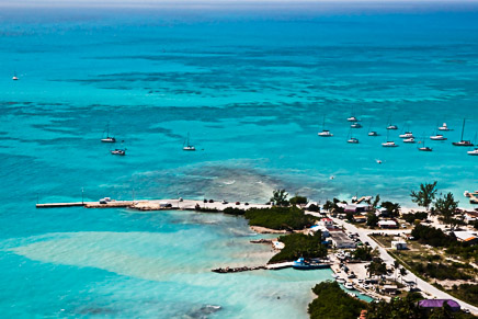
The entrance to the channel is less than a mile off the beach, between Pomato Point and Setting Point. The
green and red buoys are not immediately obvious, so do scan with your binoculars between Pomato Point and
Neptune's Treasure. Once at the entrance, steer 075° magnetic up the channel. You will see the commercial
dock and the following channel markers. It is recommended to douse your sails and start your engine before
entering the channel. Note IALA B region rules: Red Right Return.
If you cannot find the channel markers, call the Anegada Reef Hotel on VHF channel 16 and ask for assistance.
A shallow area at 18° 43.20'N and 064° 23.25'W, not shown on any chart other than
Walker's, is within the charted entrance
channel on most other charts. So if it is your first entry, send someone up forward or up the mast to scan
for shallows.
You should be prepared to douse your sails before entering the channel and motor in from the entrance, as
the wind will most likely be far enough forward that you will not be able to sail straight up the
channel. Pass directly between the entrance buoys and turn to starboard. The compass heading up the channel
from the entrance is 075° magnetic. There are two more red buoys further up the channel. Pass
within a few boatlengths of these buoys, leaving them to starboard.
The anchorage is largely grassy, and averages 6' to 8'. Mooring balls are available in the anchorage, where
it is a short dinghy ride to POTTER'S BY THE SEA. If you are plan to stay on Anegada for
more than a day or two, make sure you have ample fresh water aboard. There is no fresh water available at
Anegada, and the nearest top up would be Leverick Bay (13 nm) or Marina Cay (17 nm).
Walker Mangum has a detailed page on Navigating to Anegada
here.